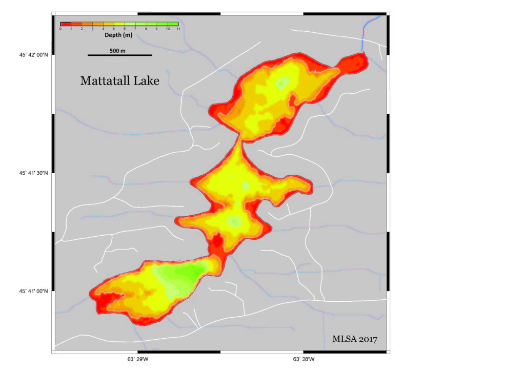
Map of Lake Depths
 In summer 2017, we took readings of water depths in the lake since the only previously available depth map was made in the 1970’s and was considered inaccurate. Over 11,000 readings were taken over a period of several weeks using a Deeper Smart Sonar Pro+ fish finder attached to a kayak. Following acquisition, the depth and position data were downloaded, corrected for variations in lake level during the period of acquisition and edited to remove bad values. The data were interpolated using the Generic Mapping Tool (GMT) software to produce a geo-referenced colour plot of lake depths (map shown below).
The map reveals details of variations of lake depths that have important implications for its water properties:
- The mean depth of the lake is 3.7 m (≈12 ft) and most of the lake is less than 6 m (≈20 ft) deep. This means that most of the lake water will be subject to surface wind-driven mixing and its temperatures will be affected by variations in surface warming throughout the summer.
- There are three small regions of deeper water in the central and northern sections that reach depths of 7.5 m (≈24½ ft), and one larger region in the south that reaches depths of 10.4 m (≈34 ft), which is deeper than the overlying mixed layer and will have different properties (i.e. the lake water will become stratified in these areas over the summer and the deeper water will not be mixed).
- There are several regions where relatively shallow depths extend away from shore as shown by the white 2 m (≈6½ ft) depth contour. Areas of the lake shallower than 1 m (3¼ ft) generally become covered by weeds during the summer but depths of 1-2 m are less obvious. Of particular note is a sill (i.e. a region of shallow water) that separates the southern and middle sections of the lake.